Introduction
The drainage pattern of Africa reflects the climate and structure of the continent. Desert areas have few rivers while equatorial region has numerous rivers. Drainage refers to the way water is removed from one area and stored in another. This is done by rivers, streams, lakes, seas and oceans.
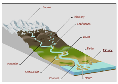
A river is a mass of water flowing in a particular channel over the land surface, from its source in a spring, marsh or glacier until it reaches its mouth, which usually opens into the sea. It may also end up in an inland swamp, lake or any other depression.

A river receives tributaries during its flow to the sea. As rivers flow, they perform the following functions i.e. erosion, transportation and deposition. Most rivers on their course from the source to the mouth display three distinct stages and these are:
- The upper course (youthful stage),
- Middle course (mature) and
- the lower stage (old or senile).
The waterfalls cut back on themselves as follows:
As the water plunges over the fall it falls heavily into the river at the foot of the fall. There is much splashing and erosion and this undercuts the rock at the base of the fall.
A cave is carved out and the top overhangs it as shown in the diagrams. After many years there is no support for the top and it falls in. The process then starts again.
Africa has many big rivers. They rise in the mountains of the plateau. In these highlands, plenty of rain falls. They flow into the seas around Africa.
- The Nile is the longest of the rivers.
- The Congo river,
- Niger river,
- Zambezi river,
- Limpopo river,
- Orange river and
- Vaal river are some more long rivers.
- The rivers which carry more water, are Congo followed by Niger.

The plateaux are at different heights above sea level. The rivers rush quickly from one level to another. They cut deep gorges. There are many big waterfalls and dangerous rapids. The plateau is very close to the coast. Big ships can thus not sail very far inland.
The Nile covers a 4000 mile distance in its course from its source in the down warped basin of L. Victoria. It is fed by tributaries such as the Blue Nile, Sobat and Atbara from Ethiopia. It has a variety of waterfalls in its lower course.
The Niger rises to the border of Sierra Leone and covers 200 miles to the Atlantic ocean. Its tributary is Benue which comes from the East.
The Congo is the second largest river in the world. Its broad shallow basin is nearly 800 miles. Surprisingly, it is the only African river with a navigable estuary, which permits sea going vessels to the part of Matadi; 80 miles inland. Within the Congo basin, there are numerous lakes.
The Zambezi river which flows through Zambia, Zimbabwe and Mozambique covers about 900 miles to reach the sea. It passes through a zigzag gorge below Victoria fall and several rapids. This river forms a delta at its mouth.
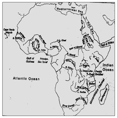
Map of Africa showing drainage features

Six major drainage networks exist in Africa. With the exception of the Chad Basin, all have outlets to the sea and all are cut by steep cataracts or rapids that impede navigation.
The Nile River, with a length of 6,695 km (4,160 mi), drains northeastern Africa and is the longest river in the world. Formed from the Blue Nile, which originates at Lake T’ana in Ethiopia, and the White Nile, which originates at Lake Victoria in eastern Africa, the Nile flows west and north before emptying into the Mediterranean Sea.
The Congo River, some 4,374 km (2,718 mi) long, drains much of central Africa. It originates in Zambia and flows north, west, and south to empty into the Atlantic Ocean.

The shows an antecedent drainage system where rivers continue with their flow even when there is a rise towards the direction the river is flowing. It cuts a gorge to continue with the flow.
The third longest African river, the Niger River in western Africa, is 4,180 km (2,600 mi) long; its upper portions are navigable only during rainy seasons. The Niger rises in the highlands of the Fouta Djallon and flows north and east before turning south to empty into the Gulf of Guinea.
The Zambezi River, 2,650 km (1,650 mi) long, originates in Zambia in southeastern Africa and flows south and east to empty into the Indian Ocean. The Zambezi is cut by various rapids, the most spectacular of which is Victoria Falls.
Draining southern Africa is the Orange River, which, with its tributary, the Vaal River, has a length of 2,100 km (1,300 mi). It rises in the Drakensberg Mountains and flows west to the Atlantic. Lake Chad, a shallow freshwater lake with an average depth of only 1.2 m (4 ft), drains nearby rivers and constitutes one of the largest inland drainage areas on the continent.

Back tilted Drainage system
The deep rift valleys of the Eastern Highlands hold a great series of lakes. This equatorial lake system includes Lakes Turkana, Albert, Tanganyika, and Nyasa (Malawi). Lake Victoria, the largest lake in Africa and the third largest in the world, is not part of this system, however; it occupies a shallow depression in the Eastern Highlands. Achieving effective control of the water supply is a major problem in Africa. Vast areas suffer low rainfall; still larger areas receive only irregular rainfall and must store water as insurance against delayed or deficient rains.
Other areas have an over abundance of water; great swamps exist, and large areas suffer from periodic flooding. In recent years, numerous dams and reservoirs have been constructed to channel water for irrigation and for hydroelectric power. The continent’s numerous rivers and the abrupt descents of the waterways have led to estimates that Africa has approximately 40 percent of the total world hydroelectric potential.