Deltas
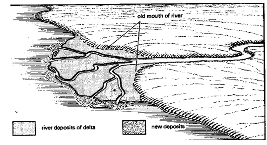
Structure of a delta
Formation of a delta
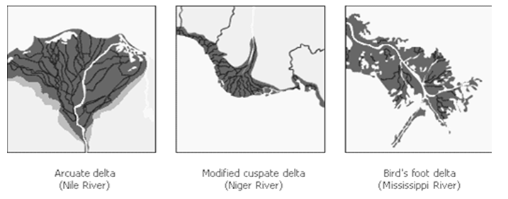
- the arctuate delta,
- the bird’s foot delta and
- Estuarine delta.
Niger River
2008/9 Schools Wikipedia Selection. Related subjects: African Geography
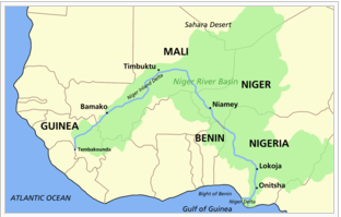
The Niger River (pronounced /ˈnaɪdʒɚ/ NYE-jer) is the principal river of western Africa, extending about 4180 km (2600 miles). Its drainage basin is 2,117,700 square kilometres (817,600 sq mi) in area. Its source is in the Guinea Highlands in the southeastern Guinea and it runs in a crescent through Mali, Niger, on the border with Benin and then throughNigeria, discharging through a massive delta, known as the Niger Delta of the Oil Rivers, into the Gulf of Guinea. The Niger is the third-longest river in Africa, exceeded only by the Nile and the Congo River (also known as the Zaïre River). Its main tributary is the Benue River.
For much of the 18th century, the exact location and course of the Niger remained virtually unknown to Europe, but many expeditions to plot the river were unsuccessful. In 1788 the African Association was formed in England to promote the exploration of Africa in the hopes of locating the Niger, and in June of 1786 the Scottish explorerMungo Park was the first European to lay eyes on the river.
Etymology
The origin of the name Niger is not certain. On early European maps it applied only to the middle reaches of the river, in modern Mali, whileQuorra or Kworra was used for the lower reaches in modern Nigeria. The name Niger was extended to cover the entire river on maps once Europeans realized that these were one and the same.
A good possibility for a source is the Tuareg phrase gher n gheren "river of rivers", shortened to ngher, a local name used along the middle reaches of the river around Timbuktu.
It is often assumed, without evidence, that Niger derives from the Latinword for "black", niger, but it would have been more likely for thePortuguese explorers who first wrote this name on their maps to have used the Portuguese word, negro, as they did elsewhere in the world. In any case the Niger is not a blackwater river, which was the motivation for all other rivers that were called black. (See Rio Negro.) Some have rationalized that 'black' may have referred to the colour of the people living on the river, but this did not happen to any other river in Africa. Therefore it would seem that the similarity between the name Niger and the Latin word niger is either coincidence, or that knowledge of Latin influenced the spelling of an indigenous name like ngher.
It is worth mentioning that the Tabula Peutingeriana records a Flumen Girin ("River Girin") with the remark Hoc flumen quidam Grin vocant, alii Nilum appellant; dicitur enim sub terra Etyopium in Nylum ire Lacum, "This river which some are naming Grin is called Nile by others, for it is said to flow under the ground of Ethiopia [i.e. Africa] into the Nile Lake".
The nations of Nigeria and Niger are named after the river. The people who live along it have a variety of names for it, such as Jeliba or Joliba "great river" in Manding, Isa Ber "big river" in Songhay, and Oya, a Yoruba River Niger goddess.
Geography
The Niger River is a relatively "clear" river, carrying only a tenth as much sediment as the Nile because the Niger's headlands are located in ancient rocks that provide little silt. Like the Nile, the Niger floods yearly; this begins in September, peaks in November, and finishes by May.
An unusual feature of the river is the Niger Inland Delta, which forms where its gradient suddenly decreases. The result is a region of braided streams, marshes, and lakes the size of Belgium; the seasonal floods make the Delta extremely productive for both fishing and agriculture.
The Niger takes one of the most unusual routes of any major river, aboomerang shape that baffled European geographers for two millennia. Its source is just 240 km (150 mi) inland from the Atlantic Ocean, but the river runs away from the sea into the Sahara Desert, then takes a sharp right turn near the ancient city ofTimbuktu (Tombouctou) and heads southeast to the Gulf of Guinea.
Ancient Romans thought that the river near Timbuktu was part of the Nile River (e.g., Pliny, N.H. 5.10), a belief also held by Ibn Battuta, while early 17th-century European explorers thought that it flowed west and joined theSenegal River. The true course was probably known to many locals, but Westerners only established it in the late 19th century, firstly mentioned in the book Travels in the Interior of Africa by the Scottish explorer Mungo Park. This strange geography apparently came about because the Niger River is two ancient rivers joined together. The upper Niger, from the source past the trading city of Timbuktu to the bend in the current river, once emptied into a now-gone lake, while the lower Niger started in hills near that lake and flowed south into the Gulf of Guinea. As the Sahara dried up in 4000-1000 BC, the two rivers altered their courses and hooked up. (This explanation is generally accepted, although some geographers disagree.)
The northern part of the river, known as the Niger bend, is an important area because it is the closest major river and source of water to that part of the Sahara desert. This made it the focal point of trade across the western Sahara, and the centre of the Sahelian kingdoms of Mali and Gao.
The surrounding Niger River Basin is one of the distinct physiographic sections of the Sudan province, which in turn is part of the larger African massive physiographic division.
Pictures
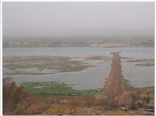
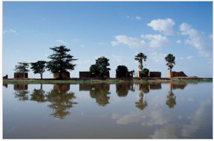
Pictures of the Niger River in Mali
|
|||||||||||||
This article is licensed under the GNU Free Documentation License. It uses material from the article "".
