Theories of Continental Drift
![]()
F.B Taylor’s
theory of continental drift
He suggested that two
landmasses moved from their polar positions due to the moon’s tidal
attractions. He stated that during
Cretaceous period, the moon came very close to the earth and exerted powerful
tidal attractions which pulled the Equator.
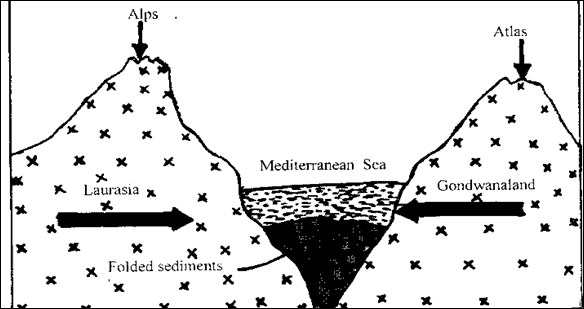
He also thought that the Atlas mountains in North Africa and the Alps
ranges in
This idea for the formation
of the two mountains also refereed to as the Geocyncline theory. It also explains the formation of fold
mountains. See the diagram below:
Collision between Gondwanaland and Laurasia.
Criticisms of Taylor’s Theory
Geophysicists argue that
however close the moon came to the earth, it could never exert enough force
to pull the continents away from their
polar locations. If it did, then the
force would have been so strong that it would have brought the earth’s rotation
to halt just one within a year.
Secondly, the theory does
not explain the formation of earlier fold mountains like the Appalachian, the
Caledonian system of Siluro – Devonian times while explaining the possible
formation of
From the criticisms of
Since the earth continues to
rotate, neither tidal attractions nor any force outside the earth is
responsible for continental drifts or organic belts.
It can be deduced that the
cause of the movements of the continents from their polar regions must be
looked for within the earth and not outside of it.
Alfred
Wegner’s Theory.
Alfred Wegner was a German
meteologist who became a famous advocate of the continental drift theory. As continental drift theory was a direct
result of two observations: Firstly, he was impressed by Antonio Snider’s reconstruction of the world after during the
Carbaniferous period. Secondly, while on a trip to
These observations seemed to
provide a solution to what had been puzzling how about the mechanism of
continental drift. These observations
made him very confident of the concept of continental drift.
Wegener, Alfred (1880-1930),
German meteorologist, noted chiefly for advocating the theory of continental
drift at a time when the technological means for proving the theory had not yet
been developed.
Wegener served as professor
of meteorology at
This landmark Scientific
American article from 1963 heralds a profound turning point in geology: the
acceptance of continental drift, or plate tectonics theory. Canadian
geophysicist J. Tuzo Wilson, one of the architects of modern geologic thought,
summarized compelling evidence that the earth’s crust is a dynamic assembly of
moving plates whose interactions explain most geological phenomena, including
volcanoes and earthquakes.
Continental
Drift
In 1912 Alfred Wegener
proposed that the continents had originated in the breakup of one
supercontinent. His idea has not been widely accepted, but new evidence
suggests that the principle is correct.
Geology has reconstructed
with great success the events that lie behind the present appearance of much of
the earth's landscape. It has explained many of the observed features, such as
folded mountains, fractures in the crust and marine deposits high on the
surface of continents. Unfortunately, when it comes to fundamental
processes—those that formed the continents and ocean basins, that set the major
periods of mountain-building in motion, that began and ended the ice
ages—geology has been less successful. On these questions there is no agreement,
in spite of much speculation. The range of opinion divides most sharply between
the position that the earth has been rigid throughout its history, with fixed
ocean basins and continents, and the idea that the earth is slightly plastic,
with the continents slowly drifting over its surface, fracturing and reuniting
and perhaps growing in the process. Whereas the first of these ideas has been
more widely accepted, interest in continental drift is currently on the rise.
In this article I shall explore the reasons why.
The subject is large and
full of pitfalls. The reader should be warned that I am not presenting an
accepted or even a complete theory but one man's view of fragments of a subject
to which many are contributing and about which ideas are rapidly changing and
developing. If it is conceded that much of this is speculation, then it should
also be added that many of the accepted ideas have in fact been speculations
also.
In the past several
different theories of continental drift have been advanced and each has been
shown to be wrong in some respects. Until it is indisputably established that
such movements in the earth's crust are impossible, however, a multitude of
theories of continental drift remain to be considered.…
The traditional rigid-earth
theory holds that the earth, once hot, is now cooling, that it became rigid at
an early date and that the contraction attendant on the cooling process creates
compressive forces that, at intervals, squeeze up mountains along the weak
margins of continents or in deep basins filled with soft sediments. This view,
first suggested by Isaac Newton, was quantitatively established during the 19th
century to suit ideas then prevailing. It was found that an initially hot,
molten earth would cool to its present temperature in about 100 million years
and that, in so doing, its circumference would contract by at least tens and
perhaps hundreds of miles. The irregular shape and distribution of continents
presented a puzzle but, setting this aside, it was thought that the granitic
blocks of the continents had differentiated from the rest of the crustal rock
and had frozen in place at the close of the first, fluid chapter of the earth's
history. Since then they had been modified in situ, without migrating.
This hypothesis, in its
essentials, still has many adherents. They include most geologists, with
notable exceptions among those who work around the margins of the southern
continents. The validity of the underlying physical theory is defended by some
physicists. On the other hand, a number of formidable objections have been
raised by those who have studied radioactivity, ancient climates, terrestrial
magnetism and, most recently, submarine geology. Many biologists have also
thought that, although the evolution and migration of later forms of
life—particularly since the advent of mammals—could be satisfactorily traced on
the existing pattern of continents, the distribution of earlier forms required
either land bridges across the oceans—the origin and disappearance of which are
difficult to explain—or a different arrangement of the continents.
The discovery of
radioactivity altered the original concept of the contraction theory without
absolutely invalidating it. In the first place, the age of the earth could be
reliably determined from knowledge of the rate at which the unstable isotopes
of various elements decay and by measurement of the ratios of daughter to
parent isotopes present in the rocks. These studies showed the earth to be much
older than had been imagined, perhaps 4.5 billion years old. Dating of the
rocks indicated that the continents are zoned and have apparently grown by
accretion over the ages. Finally, it was found that the decay of uranium,
thorium and one isotope of potassium generates a large but unknown supply of
heat that must have slowed, although it did not necessarily stop, the cooling
of the earth.
The rigid earth now appeared
to be less rigid.… Calculations of the viscosity of the interior … led to the
realization that the earth as a whole behaves as though a cool and brittle
upper layer, perhaps 100 kilometers thick, rests on a hot and plastic interior.
All the large topographical features—continents, ocean basins, mountain ranges
and even individual volcanoes—slowly seek a rough hydrostatic equilibrium with
one another on the exterior. Precise local measurements of gravity showed that
the reason some features remain higher than others is that they have deeper,
lighter roots than those that are low. The continents were seen to float like
great tabular icebergs on a frozen sea.
Everyone could agree that in
response to vertical forces the outer crustal layer moved up and down, causing
flow in the interior. The crux of the argument between the proponents of fixed
and of drifting continents became the question of whether the outer crust must
remain rigid under horizontal forces or whether it could respond to such forces
by slow lateral movements.
Gondwanaland
and "Pangaea"
Suggestions that the
continents might have moved had been advanced on various grounds for centuries.
The remarkable jigsaw-puzzle fit of the Atlantic coasts of Africa and
The first comprehensive
theory of continental drift was put forward by the German meteorologist Alfred
Wegener in 1912. He argued that if the earth could flow vertically in response
to vertical forces, it could also flow laterally. In support of a different
primeval arrangement of land masses he was able to point to an astonishing
number of close affinities of fossils, rocks and structures on opposite sides
of the Atlantic that, he suggested, ran evenly across, like lines of print when
the ragged edges of two pieces of a torn newspaper are fitted together again.
According to Wegener all the continents had been joined in a single
supercontinent about 200 million years ago, with the Western Hemisphere
continents moved eastward and butted against the western shores of Europe and
Africa and with the Southern Hemisphere continents nestled together on the
southern flank of this "Pangaea." Under the action of forces
associated with the rotation of the earth, the continents had broken apart,
opening up the
Between 1920 and 1930
Wegener's hypothesis excited great controversy. Physicists found the mechanism
he had proposed inadequate and expressed doubt that the continents could move
laterally in any case. Geologists showed that some of Wegener's suggestions for
reassembling the continents into a single continent were certainly wrong and
that drift was unnecessary to explain the coincidences of geology in many
areas. They could not, however, dispute the validity of most of the
transatlantic connections. Indeed, more such connections have been steadily
added.
It was the discovery of one
of these connections that prompted my own recent inquiries into the subject of
continental drift. A huge fault of great age bisects
Many geologists of the
Southern Hemisphere, led by Alex. L. Du Toit of
The compelling evidence for
the existence of a Gondwanaland during the Mesozoic era—the "Age of
Reptiles"—has been reinforced by the findings made in
Many suggestions have been
made as to how to create and destroy the land bridges needed to explain the
biological evidence without moving the continents. Some involve isthmuses and
some involve whole continents that have subsided below the surface of the
ocean. But the chemistry and density of continents and ocean floors are now
known to be so different that it seems even more difficult today to raise and
lower ocean floors than it is to cause continents to migrate.
Convection in
the Mantle
Over the abyssal trenches in
the sea floor that are associated with the island arcs of
Arthur Holmes of the
Convection currents in the
mantle now play the leading role in every discussion of the large-scale and
long-term processes that go on in the earth. It is true that the evidence for
their existence is indirect; they flow too deep in the earth and too slowly—a
few centimeters a year—for direct observation. Nonetheless their presence is
supported by an increasing body of independently established evidence and by a
more rigorous statement of the theory of their behavior.…
Perhaps the strongest
confirmation has come with the discovery of the regions where these currents
appear to ascend toward the earth's surface. This is the major discovery of the
recent period of extraordinary progress in the exploration of the ocean bottom,
and it involves a feature of the earth's topography as grand in scale as the
continents themselves. Across the floors of all the oceans, for a distance of
40,000 miles, there runs a continuous system of ridges. Over long stretches, as
in the mid-Atlantic, the ridge is faulted and rifted under the tension of
forces acting at right angles to the axis of the ridge. Measurements first
undertaken by Sir Edward Bullard of the
Most oceanographers now
agree that the ridges form where convection currents rise in the earth's mantle
and that the trenches are pulled down by the descent of these currents into the
mantle. The possibility of lateral movement of the currents in between is
supported by evidence for a slightly plastic layer—called the
asthenosphere—below the brittle shell of the earth. Seismic observations show
that the speed of sound in this layer suddenly becomes slower, indicating that
the rock is less dense, hotter and more plastic. These observations have also
yielded evidence that the asthenosphere is a few hundred kilometers thick,
somewhat thicker than the crust, and that below it the viscosity increases
again.
Here, then, is a mechanism,
in harmony with physical theory and much geological and geophysical
observation, that provides a means for disrupting and moving continents. It is
easy to believe that where the convection currents rise and separate, the surface
rocks are broken by tension and pulled apart, the rift being filled by the
altered top of the mantle and by the flow of basalt lavas. In contrast to
earlier theories of continental drift that required the continents to be driven
through the crust like ships through a frozen sea, this mechanism conveys them
passively by the lateral movement of the crust from the source of a convection
current to its sink. The continents, having been built up by the accumulation
of lighter and more siliceous materials brought up from below, are not dragged
down at the trenches where the currents descend but pile up there in mountains.
The ocean floor, being essentially altered mantle, can be carried downward;
such sediments as have accumulated in the trenches descend also and, by
complicated processes, may add new mountains to the continents. Since the
material near the surface is chilled and brittle, it fractures, causing
earthquakes until it is heated by its descent.
From the physical point of
view, the convection cells in the mantle that drive these currents can assume a
variety of sizes and configurations, starting up and slowing down from time to
time, expanding and contracting. The flow of the currents on the world map may
therefore follow a single pattern for a time, but the pattern should also
change occasionally owing to changes in the output and transfer of heat from
within. It is thus possible to explain the periodicity of mountain-building,
the random and asymmetrical distribution of the continents and the abrupt breakup
of an ancient continent.
Some geophysicists consider
that isostatic processes [the tendency for the earth’s crust to seek
gravitational equilibrium] set up by gravitational forces may suffice to cause
the outer shell to fracture and to slip laterally over the plastic layer of the
asthenosphere. This mechanism would not require the intervention of convection
currents. Both mechanisms could explain large horizontal displacements of the
crust.
Evidence from
Terrestrial Magnetism
Fresh evidence that such great
movements have indeed been taking place has been provided by two lines of study
in the field of terrestrial magnetism. On the one hand, surveys of the earth's
magnetic field off the coast of
Evidence of a more general
nature in favor of continental drift comes from the studies of the
"remanent" magnetism of the rocks, to which Runcorn, P. M. S.
Blackett of the
Some physicists and
biologists are now prepared to accept continental drift, but many geologists
still have no use for the hypothesis. This is to be expected. Continents are so
large that much geology would be the same whether drift had occurred or not. It
is the geology of the ocean floors that promises to settle the question, but
the real study of that two-thirds of the earth's surface has just begun.
The Oceanic
One decisive test turns on
the age of the ocean floor. If the continents have been fixed, the ocean basins
should all be as old as the continents. If drift has occurred, some regions of
the ocean floor should be younger than the time of drift.…
Significantly, it turns out
that the age of the islands in the
A
Double Hypothesis
We have therefore advanced two related hypotheses: first, that where
adjacent continents were once joined a median ridge should now lie between
them; second, that where such continents are connected by lateral ridges they
were once butted together in such a manner that points marked by the shoreward
ends of these ridges coincided. If this is correct, it provides a unique method
for reassembling continents that have drifted apart.…
Without doubt the most severe
test of this double hypothesis is presented by the
The mid-ocean ridge
separating
There are therefore enough
connections to draw all the continents together, reversing the trends of motion
indicated by the mid-ocean ridges and using the continental ends of pairs of
lateral ridges as the means of matching the coast lines together. The ages of
the islands and of the coastal formations suggest that about 150 million years
ago, in mid-Mesozoic time, all the continents were joined in one land mass and
that there was only one great ocean. The supercontinent that emerges from this
reconstruction is not the same as those proposed by Wegener, Du Toit and other
geologists, although all have features in common. The widespread desert
conditions of the mid-Mesozoic may have been a consequence of the unusual
circumstance that produced a single continent and a single ocean at that time.
Since its approximate location with respect to latitude is known, along with
the location of its major mountain systems, the climate in various regions
might be reconstructed and compared with geological evidence.…
 Breakup of the Supercontinent
If it can be assumed that
the proposed Mesozoic continent did exist and spread apart, geology provides
some guide to the history of its fragmentation.…
It seems reasonable to
suggest, particularly from the geology of the
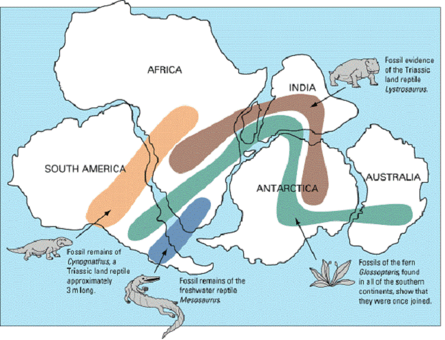
Figure 2: Wegener used fossil evidence
to support his continental drift hypothesis. The fossils of these organisms are
found on lands that are now far apart. Wegener suggested that when the
organisms were alive, the
lands were joined and the organisms were living side-by-side.
A few million years ago
activity in this system decreased. The Atlantic rift now became more active
again, producing renewed uplift in the
The presently expanding
rifts run mostly north and south or northeasterly so that dominant easterly and
westerly compression of the outer crust is absorbed by overthrusting and
sinking of the crust along the eastern and western sides of the "ring of
fire" around the Pacific. The westward-driving pressure of the South
Atlantic portion of the Mid-Atlantic Ridge has forced the continental block of
The theory I have outlined
may be highly speculative, but it is indicative of current trends in thought
about the earth's behavior. The older theories of the earth's history and
behavior have proved inadequate to meet the new findings, particularly those
from studies of terrestrial magnetism and oceanography. In favor of the
specific details suggested here is the fact that they fit observations and are
precise enough to be tested.
Simple
Explanation Of Wegner’s Theory
Accordingly in 1910, Wegner
formulated his continental drift theory and in 1912, he published it. Wegner’s theory of continental drift is based
on rifting and drifting of land masses. The
theory is explained as follows:
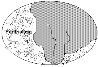
About 200 million years
before the present, there was only one super continent called Pangaea – lying
near the south pole. It was surrounding
by a giant ocean known as Panthalassa. See the diagram
About 180 million years ago,
the Pangaea split or rifted into two continental blocks that is Laurasia which
drifted Northwards and Gondwanaland which remained where it was. The two landmasses were separated at sea
known as Tethys. Gondwanaland began to
break up causing

About 135 million years ago
(before the present) Gondwanaland and Laurasia drifted northwards. The Laurasia split into Eurasia and North
America, while Gondwanaland split into
Africa,

About 65 million years
before the present

Wegner thought that the
northward drift resulted from the gravitational attraction of the Equatorial
bulge (Centripetal force) and the west ward drift was due to the tidal
attractions of the moon and the sun causing the continents to move slowly on
relation to the earth’s rotation.
The continents today and 50
million years from now.
Criticisms of
Wegner’s Theory
Firstly, Wegner was a meteologist and not a
geologist, he therefore had no business in the field of geology.
Secondly, Wegner never
bothered to explain the forces he thought were responsible for continental
drift.
Thirdly, Geologists argue
that both centrifugal force (gravitational
attraction of the Equatorial bulge) and tidal attractions are many million
times too small to drag continents from their original positions.
It is now generally agreed
that no force from outside the earth may be
strong enough to cause continental drift. Whatever the force it must be
from within the earth.
The sun and moon both do
exert tidal attractions on the earth but they are too weak to resist the
earth’s rotation and raise mountain ranges.
However, credit should be
given to Wegner’s theory because of the following reasons:
· His theory excited so much
research into the concept of continental drift.
·
He gathered an impressive heap of evidence to support his theory such
evidence include: Jigsaw – like fit of coasts, Similar rock sequences
· Existence of similar flora
and fauna of the various continents of Equatorial forests of the Amazon, Asian,
and
The Convection Current Theory.
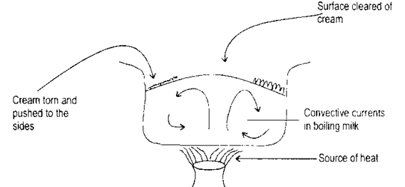
The publishers of this
theory advanced that the interior of the
earth behaves like boiling milk and the earth crust behaves like the cream
being torn and pushed to the sides.
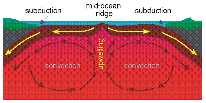
Figure 4b: Diagram of convection within Earth's mantle.
This theory was later
developed by an American geologist Henry Hess in the mid 1960s into the
theory of sea floor spreading.
The Theory of
Sea Floor Spreading
During the 1950s, as people
began creating detailed maps of the world’s ocean floor, they discovered a
mid-ocean ridge system of mountains nearly 60,000 km (nearly 40,000 mi) long.
This ridge goes all the way around the globe.
American geologist Harry H. Hess
proposed that this mountain chain was the place where new ocean floor was
created and that the continents moved as a result of the expansion of the ocean
floors. This process was termed seafloor spreading by American geophysicist
Robert S. Dietz in 1961. Hess also proposed that since the size of the earth
seems to have remained constant, the seafloor must also be recycled back into
the mantle beneath mountain chains and volcanic arcs along the deep trenches on
the ocean floor.
These studies also found marine
magnetic anomalies, or differences, on the sea floor. The anomalies are
changes, or switches, in the north and south polarity of the magnetic rock of
the seafloor. Scientists discovered that the switches make a striped pattern of
the positive and negative magnetic anomalies: one segment, or stripe, is
positive, and the segment next to it is negative. The stripes are parallel to
the mid-ocean ridge crest, and the pattern is the same on both sides of that
crest. Scientists could not explain the cause of these anomalies until they
discovered that the earth’s magnetic field periodically reverses direction.
To explain how sea floor spreading takes place Hess
suggested that the earth’s interior (mantle) behaves some what like a giant
convection system. Materials heated by
radioactive elements on the earth’s interior slowly rise the lisosphere).
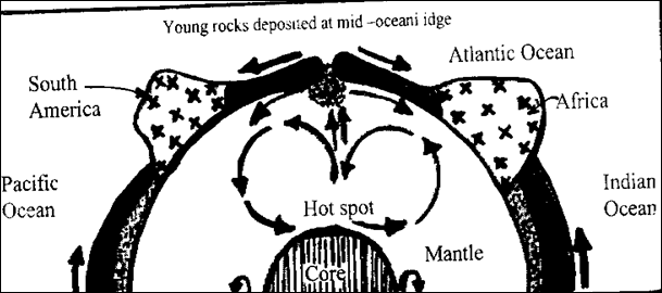
Diagram showing how plates
move.
There were two criticisms of
Sea Floor Spreading. One of them is that the theory only explains the formation
of
How the theory of
plate tectonics and sea floor spreading to explain the evolution of major
structural and relief
This
theory attempts to explain how continents are ruptured by thermal convective currents rising from beneath ocean ridges.
Because of opposing tensional forces, rifting
is caused, earthquakes are generated beneath the ridges and new crustal
material is emitted into the cracks created by lateral drifting of the raptured
continental blocks. This raptured material is spread over the ocean floor as
new oceanic crust.
Candidate should then use the above
background knowledge to explain the evolution of East African landforms.
Thermal convection within the mantle is
responsible for the rupture of continental blocks. It is at such points of
rupture that molten rock (magma) is ejected onto the surface of the earth or
trapped within the crust. This process is known as vulcanicity.
Draw a diagram to illustrate the above i.e. a
volcano.
N.B. The candidate should then cite 'volcanic
landscapes e. g.
·
side
vent or parasitic cone or secondly cone or subsidiary cone for example on
Muhavura in south western Uganda.
·
Crater
containing Lake for example lake Ngozi near Mbeya in Tanzania.
·
Composite
volcanic cone of layers of ash and larva for example Mt. Meru. Mt. Kilimanjaro
and Mt. Elgon.
·
Lava
flow on Mt. Kenya.
·
Steam
and gas jets for example Mt. Longonot in Kenya.
·
Volcanic
Neck (the hard rock or plug that remains, while much of the rest has been
eroded away) for example Batian and Nelion Peaks on Mt. Kenya and Mt.. Torero
in Uganda.
·
Lava
sheet which has welled up along a fault line for example Aberdare Mts. in
Kenya.
·
Caldera
for example Mt. Longonot in Kenya.
·
Ring
crater the raised rim is made up of ash and cinder for example Lake Katwe
western Uganda.
·
Explosion
crater for example many exist in between Elizabeth National Park, Western
Uganda.
·
Ash
and Cinder cones for example lowland area near the Mufumbiro Ranges in Uganda.
·
Batholith
for example at Singo in Uganda. Tanganyika batholith in Tanzania.
·
Dyke
- an intrusion of lava across a bedding plains in Turkana in Kenya.
N.B. A few examples of the above features can
do.
Where lateral forces are responsible for
tensional forces which cause faulting. Then illustrate how faulting takes place
through tensional and compressional theories diagrammatically. The candidate
should then cite examples of landforms due to faulting. These include
the followings:
Block
mountains or Horsts- for example Ruwenzori in Uganda Usambara Mts., the
Ulugurus, Mbeya, Range and the Iramha Plateau all of which are found in
Tanzania.
· Fault
- Escarpments for example Manyara in Tanzania and Butiaba in Uganda,
· Fault
scarps for example Elgayo scarp in Kenya and Chunya scarp in southern Tanzania.
· Rift
Valleys for example western Rift and the Gregory Rift.
· Waterfalls
for example Karuma and Murchison falls in Uganda and Nyahururu falls in Kenya.
· Fault
Guided valleys for example Aswa in northern Uganda, Kerio, Ewaso Ngiro, and
Melawa in Kenya. In Tanzania they include: Mzimu and Nglumi rivers.
· Rift
valley lakes for example Tanganyika in Tanzania, Albert in Uganda and Turkana
in Kenya.
· Reversal
of drainage - for example Kafu and Katonga rivers in Uganda and Kagera river
which begins in Rwanda.
· Rejuvenated River valleys for example the Sine river in Tanzania, the Mwachi river in Kenya

The
Earth's surface is made up of continents and ocean basins. Several theories have been advanced to
explain the origins of continents and ocean basins. Some theories do not relate
to lateral (horizontal) movement of the crust. They include Isostasy,
Tetrahedral and Moon theories. Other theories deal with small and large scale
horizontal movements of the crust. These collectively fall under continental
drift. They include the theories of Wegener and Taylor as well as the
"expanding Earth", "sea floor-spreading" and
"plate-tectonics" theories. These are the theories to be discussed in
this question.
Continental
drift is a hypothesis that states that continental masses have changed their
relative positions as a result of fragmentation and moving apart of original
land masses. It is now widely believed that continents moved through time and
are still moving even today. Several theories of continental drift have been
advanced as discussed below.
The expanding Earth theory is one of those theories. According to the theory, the Earth was at one time a small planet with a thin continental layer at the surface. The interior of the Earth expanded and forced the outer crust to crack. The crust was therefore divided into separate crustal blocks (continents). As the Earth continued to expand, the cracks widened and the gaps grew wider as crustal blocks moved away from each other. The widening gaps became oceans, while the crustal blocks became continents.
(Note: This theory
was originally advanced to explain distribution of oceans and basins but since
it involves horizontal movement of the crust, it can also pass as a theory of
continental drift).
In
1910, F.B. Taylor came up with another theory of continental drift. According
to this theory, originally there were two big land masses, namely, Laurasia and
Gondwanaland. Laurasia was located near the present day North Pole from where
it later drifted southwards towards the equator. Gondwanaland was located somewhere
near the South Pole and it also drifted but this Time northwards towards the
equator. Where there was resistance, the crust experienced uneven flow and at
times formed mountains. In some cases, the crust stretched and split forming
troughs that became ocean basins,
According
to Taylor when Laurasia and Gondwanatand met, the Atlas and Alpine fold
mountains were formed, Taylor's theory, however seems to have some weaknesses,
In the first place, it does not explain the formation of earlier fold mountains
like the Caledonian system of Siluro-Devonian times and the Hercynian system of
Mid-Permian and Carboniferous periods. In the- second place, it seems highly
doubtable that the moon could ever exert enough force to pull the gigantic continents.
In
1915, Alfred Wegener, a German Climatologist and Geophysicist published a book
titled 'Origin of continents and ocean basins' in which he argued that,
continents had changed their positions over time. This led to what is now known
as Wegener's theory of continental drift. According to this theory, the present
day continents originated from one land mass known as "Pangaea", This
single-sialic land mass is thought to have been positioned somewhere near the
south pole and was surrounded by a big expanse of water known as
"Panthalassa". This land mass later split up into two super
continents known as Laurasia (Atlantis) and Gondwanaland. The two were
separated by a narrow water body known as the "
During
the late Palaeozoic and early Mesozoic eras, numerous cracks developed in the
land masses leading to separation and consequent drifting. Finally during the
cretaceous period, approximately 135-70 million years ago, the land masses
completely broke up. Gondwanaland gave rise to the "Southern Continents",
namely, Africa, South America, Antarctica, Australia, the Sub-continent of
India and the numerous islands in the southern hemisphere. Laurasia broke up to
give rise to North America, Europe, Asia and other land masses in the northern
hemisphere such as Greenland and Iceland, Wegener contends that the Himalayas
were formed when the sub-continent of India collided with the Asian land mass.
Wegener
suggested that breaking-up was due to centriftigal force but this explanation
was dismissed by some geologists as unconvincing. Nevertheless his theory was
exciting and was later followed up by other scholars.
Another
attempt to explain continental drift is the sea floor-spreading theory. One of
the modem theories of continental drift, the sea floor spreading theory is
basically the work of a geologist by the names of H. Hess. It was propounded in
the 1960s. According to Hess, the interior of the Earth is in a molten
(semi-fluid) state because of great heat resulting from radioactivity and
geo-chemical reactions.
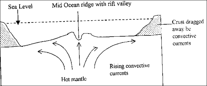
This
tremendous heat causes melting or near-melting of rocks of the interior of the
Earth (mantle rocks). These molten and therefore mobile rocks tend to rise from
within the mantle in form of convective current. As they reach the base of the
Earth's crust, they flow horizontally beneath and drag the crust in the
direction to which they are moving. This therefore causes movements of the
crust, hence continental drift.
Where
the current is moving towards the Earth's surface, new rocks are deposited.
This is what happens at mid ocean ridges. The newly deposited rocks displace
the old ones and the ocean floor therefore widens, that is, the sea floor
spreads apart.
The
theory of plate-tectonics is the most modem of all theories of continental drift,
It is a development of the sea floor-spreading theory and other theories of
continental drift. The theory presupposes that the Earth crust is divided into
a number of blocks or rafts known as tectonic plates. These relatively light
plates "float" and move on top of the Earth's interior. A plate is so
rigid that if one part of it moves, the rest also moves as a unit. Consider,
for example, a thin sheet of plywood laid out on a table. If you push one end
of the rigid plywood, the whole of it will move. The plates are moved by the
energy originating from the Earth's interior. Within the interior, there is
intense heat originating from radioactivity and gee-chemical reactions. The
heat tends to cause rock-melting so that molten rock facilitate convection and
lateral movement of overlying plates. It
should be remembered that continents form an integral part of the crustal
plates and therefore as plates are transported by the convection current, the
continents move with them. (This can be likened to logs moving on a glacier).
In this way, continental drift slowly but steadily takes place.
There
are several lines of evidence to prove that continental drift is a reality.
Geometrical fit of coastlines (Jig-saw fit) is one of the earliest evidences. It
has been studied and observed that some coastlines on both sides of the
Similarity
of rocks is another evidence used to justify continental drift. There are
remarkable similarities between rocks found in different land masses of the
southern continents. In Africa, the rocks of
Studies
from palaeoclimatology have provided farther evidence that justifies
continental drift. This is in connection with glacial deposits. Carboniferous
glacial deposits exist in tropical and subtropical lowlands. They, for example,
exist in
The
occurrence of laterite in North America and certain parts of
The
existence of coral reefs in cold
Similarity
of oil beds is yet another evidence of continental drift. It has been found
out, for example, that the oil beds of
The
existence of fold mountains justifies movement of plates and therefore
continents. Fold mountains only form when there are compressional forces acting
in the same direction. These mountains must have formed when crustal plates
moved towards each other. The fact that crustal plates moved therefore proves
that continents also moved and are perhaps still moving.
The
existence of big amounts of salt evaporites in some cold parts of
Palaeomagnetism
refers to ancient or fossil magnetism in rocks, it is established from
geological laboratory research on rocks of the Earth's crust which are always
magnetised by the Earth's magnetic field at the time of formation,
Palaeomagnetism is based on the fact that igneous rocks when cooled retain or
preserve some magnetic properties which at the time of magnetization, point to
the Earth's North-South Poles. It follows that if young rocks are formed, they
are magnetised and their magnetic poles point North and South at the time of magnetization.
Research on rocks in
Tectonic
activity and instability is considered to be the most modern evidence of
continental drift. It has been proved that the gap between Africa and
Conclusively,
several theories have been advanced to explain continental drift. Like all
theories, some of them suffer from defects and have been criticised, Others
seem to be quite reasonable and even have scientific proof Modern evidence
based on palaeomagnetism and movement of plates will definitely stand the test
of time.