Plate Tectonics Theory.
The
idea of plate tectonics is a very recent one which caused a revolution in
geological sciences in the 1960s. Plate tectonics is a process through which
movements of the Earth crust are effected so that the surface is divided along
lines of weakness pre-determined by the internal structure of the Earth. This
division has produced a number of separate cmstal blocks known as tectonic
plates. These plates are relatively light and therefore "float" on
the denser rocks of the mantle and asthenosphere. The plates are also mobile
and move extremely slowly on rocks of the upper mantle, driven by convective
currents. A given plate is so rigid that if one part moves, then the rest also
moves. A plate therefore moves as a unit
Tectonic
plates move because of energy generated by radioactivity and geo- chemical
reactions in the interior of the Earth. The resultant intense heat causes
partial melting of rocks which then rise up in form of convection current and
drive the plates,
There
are three major plate boundaries, namely, divergent, convergent and transform.
A divergent plate boundary is said to exist when plates are moving slowly away
from each other. New rocks come to the surface and push old ones away. This
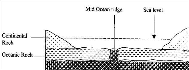
phenomenon is therefore closely linked with sea floor-spreading On ocean
floors, this produces an under-water mountain known as the mid-ocean ridge. If
plates move apart beneath a continent, continental land masses undergo faulting
and this causes formation of several landforms such as grabens and rift
valleys. Divergence tends to lead to expansion of the crust.

A
convergent boundary is said to exist when plates move and meet, that is.
converge. When this happens one of the plates is forced to descend into the
Earth's interior where it becomes slowly heated and eventually assimilated into
the surrounding material. It is the dense oceanic lithosphere plate that
descends beneath the continental plate. Continental rocks are rather light and
so do not sink. Instead, they are compressed into fold mountains when the
plates meet Convergence tends to cause contraction of the crust.

The
transform boundary exists where two tectonic plates are sliding past each
other. The plates by pass each other without creating new or destroying the old
lithosphere but sometimes causing earthquakes as the two surfaces rub against
each other. The San Andreas fault in
Plate
tectonics causes movements in the crust and thus formation of landforms It
causes the formation of rift valleys, block mountains, down warped basins,
volcanoes and several other related landforms. In other words, all these
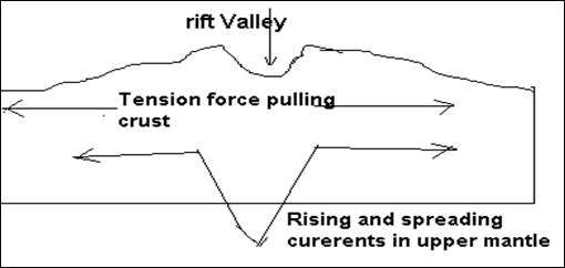
features can be explained in terms of plate tectonics, Where plates diverge or
move. Away from each other beneath a continent, they tend to pull the Earth's
surface apart resulting in tensional forces. If tension is great, the crust
fractures and this can lead to the formation of a rift valley. This is how the
East African rifl: valley especially the Gregory branch was formed.

Plate
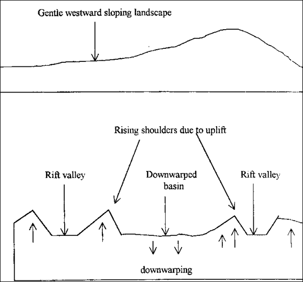
tectonics also causes formation of down warped basins. A down warped basin can
be an indirect effect of faulting. The down warped basins occupied by lakes
Kyoga and Victoria are believed to be connected to the formation of the East
African rift valley. In the process of formation of the rift valley in

Another
alternative explanation but which is also related to plate tectonics is the
effect of converging convective currents below the Earth's crust. It has been
suggested that when convective currents sink back into the interior below the
crust, they pull the Earth's surface towards the Earth's centre leading to down
Currents
sink back into the interior and pull Earth's crust downwards Plate tectonics
also causes vertical movement of the cmst. As convective currents rise towards
the surface, they exert an upward push on the crust leading to uplift This has
led to the formation of block mountains in
definitely
agrees with formation of block mountains according to the theory of
differential uplift. The block
mountains in
Plate
tectonics is also responsible for the formation of volcanic landforms in
Plate
tectonics is therefore greatly responsible for the formation of many landforms
in
Similarly,
while plate tectonics originally created intrusive igneous features below the
crust, it is not responsible for their subsequent exposure at the surface of
the Earth. If the sub-aerial exogenic processes of weathering and differential
erosion had not taken place, these igneous intrusions would have remained
buried underground. In that case the impressive inselbergs in the Northern and
North Eastern parts of
External
or exogenic processes of weathering, erosion and deposition have all played a
big role in the evolution of today's landforms in
The
process of erosion has also created many landforms in
Lacustrine
and marine (wave) erosion has produced wave-cut platforms, cliffs, caves,
arches and stacks. These are evident at the coast of East
Deposition
is another process that explains the present landforms in
Finally
wave deposition has led to the formation of such depositional landforms as
spits, mud flats, tombolos, sand bars and beaches. Big beaches abound on the
East African coast while small ones also exist on the northern shores of lake
Victoria at
Thus
in conclusion, plate tectonics is indeed a fundamental process responsible for
the formation of landforms in East Africa- It is responsible for the formation
of a "background structure". Other external processes, however, have
operated on this initial structure and modified it to give rise to the present
landforms. This is why it is right and fitting to maintain that plate tectonics
is not responsible for the formation of the present landforms to a "full
extent". These landforms are a product of interaction of processes of
which plate-tectonics is only a part.