Natural Regions

Sub-Saharan Africa
2008/9 Schools Wikipedia Selection. Related subjects: African Geography
Sub-Saharan Africa is a geographical term used to describe the area of the African continent which lies south of the Sahara, or those African countries which are fully or partially located south of the Sahara.
It contrasts with North Africa, which is part of the Arab world.
The Sahel is the transitional zone between the Sahara and the tropical savanna (the Sûdân region) and forest-savanna mosaic to the south.
The Horn of Africa and Southern Sudan are geographically part of sub-Saharan Africa, but nevertheless show strong Middle Eastern influence and are also part of the Arab world.
The Sub-Saharan region is also known as Black Africa, in reference to its " black" populations, in contrast to the " Caucasoid" or " Melanochroi" inhabitants of North Africa. The term bilâd as-sûdân itself literally translates to "land of the blacks".
Geography
Sub-Saharan Africa covers an area of 24.3 million square kilometers.
Since around 5,400 years ago , the Saharan and sub-Saharan regions of Africa have been separated by the extremely harsh climate of the sparsely populated Sahara, forming an effective barrier interrupted by only the Nile River in Sudan, though the Nile was blocked by the river's cataracts. The Sahara Pump Theory explains how flora and fauna (including Homo sapiens) left Africa to penetrate the Middle East and beyond to Europe and Asia. African pluvial periods are associated with a "wetSahara" phase during which larger lakes and more rivers exist.
Climate zones and ecoregions
Sub-Saharan Africa has a wide variety of climate zones or biomes. South Africaand the Democratic Republic of the Congo in particular are consideredMegadiverse countries.
- the Sahel cuts across all of Africa at a latitude of about 10° to 15° N. Contries that include parts of the Sahara proper in their northern territories and parts of the Sahel in their southern region include Mali, Niger, Chad andSudan.
- south of the Sahel, there is a belt of savanna, ( Guinean forest-savanna mosaic, Northern Congolian forest-savanna mosaic) widening to include most of Southern Sudan and Ethiopia in the east ( East Sudanian savanna).
- the Horn of Africa includes arid semi-desert along its coast, contrasting with savanna and moist broadleaf forests in the interior of Ethiopia.
- Africa's tropical rainforest stretches along the southern coast of West Africa and dominates Central Africa (the Congo) west of the African Great Lakes
- the Eastern Miombo woodlands are an ecoregion of Tanzania, Malawi, andMozambique.
- the Serengeti ecosystem is located in north-western Tanzania and extends to south-western Kenya.
- the Kalahari Basin includes the Kalahari Desert surrounded by a belt of semi-desert
- The Bushveld is a tropical savanna ecoregion of Southern Africa.
- the Karoo is a semi-desert in western South Africa.
History
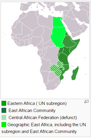
East Africa
The distribution of the Nilo-Saharan linguistic phylum is evidence of a certain coherence of the central Sahara, the Sahel and East Africa in prehistoric times. Ancient Nubia appears to have acted as a link connecting Ancient Egypt to sub-Saharan Africa, based on traces of prehistoric south-to-north gene flow.Kush, Nubia at her greatest phase is considered sub-saharan Africa's oldest urban civialization. Nubia was a major source of gold for the ancient world. Accordingly, the Old Nubian language is itself a member of the Nilo-Saharan phylum. Old Nubian (arguably besides Meroitic) represents the oldest attested African language outside the Afro-Asiatic group.
The Axumite Empire spanned the southern Sahara and the Sahel along the western shore of the Red Sea. Located in northern Ethiopia and Eritrea, Aksum was deeply involved in the trade network between India and theMediterranean. Emerging from ca. the 4th century BC, it rose to prominence by the 1st century AD. It was succeeded by the Zagwe dynasty in the 10th century.
Somalia was under the control of Ethiopian Empire until 1527, when a revolt under Imam Ahmad ibn Ibrihim al-Ghazi led to an invasion of Ethiopia. The Ajuran dynasty ruled parts of East Africa from the 16th to 20th centuries.
Kenya's proximity to the Arabian Peninsula invited colonization, and Arab and Persian settlements sprouted along the coast by the 8th century. During the first millennium AD, Nilotic and Bantu-speaking peoples moved into the region, and the latter now comprise three-quarters of Kenya's population. In the centuries preceding colonization, the Swahili coast of Kenya was part of the east African region which traded with the Arab world and India especially for ivory and slaves. Swahili, a Bantu language with many Arabic, Persian and other Middle Eastern and South Asian loan words, developed as a lingua franca for trade between the different peoples.
In 1498 Vasco da Gama became the first European to reach the East African coast, and by 1525 the Portuguesehad subdued the entire coast. Portuguese control lasted until the early 18th century, when Arabs from Omanestablished a foothold in the region. Assisted by Omani Arabs, the indigenous coastal dwellers succeeded in driving the Portuguese from the area north of the Ruvuma River by the early 18th century.
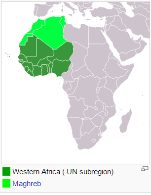
West Africa
The Nok culture, known from a type of terracotta figure found in Nigeria, dating to 500 BC - AD 200.
There are a number of medieval kingdoms of the southern Sahara and the Sahel, based on trans-Saharan trade, including the Ghana Empire and the Mali Empire, Songhai Empire, the Kanem Empire and the subsequent Bornu Empire. The Benin Empire was a pre-colonial state of Nigeria (1440-1897).
The kingdoms of Ifẹ and Oyo in the western block of Nigeria became prominent about 700-900 and 1400 respectively. Another prominent kingdom in south western Nigeria was the Kingdom of Benin whose power lasted between the 15th and 19th century. Their dominance reached as far as the well known city of Eko which was named Lagos by the Portuguese traders and other early European settlers. In the 18th century, the Oyo and theAro confederacy were responsible for most of the slaves exported from Nigeria.
Following the Napoleonic wars, the British expanded trade with the Nigerian interior. In 1885 British claims to a West African sphere of influence received international recognition and in the following year the Royal Niger Company was chartered under the leadership of Sir George Taubman Goldie. In 1900 the company's territory came under the control of the British Government, which moved to consolidate its hold over the area of modern Nigeria. On January 1, 1901 Nigeria became a British protectorate, part of the British Empire, the foremost world power at the time.
Central Africa
The Bantu expansion has its original nucleus in West Africa, dividing into a Western and an Eastern Bantu group by about 1500 BC. The Eastern group has its nucleus at Urewe, in the first half of the 1st millennium BC. There follow a series of southwards advances, establishing a Congo nucleus by the end of the 1st millennium BC. In a final movement, the Bantu expansion reaches Southern Africa in the 1st millennium AD.
Southern Africa
Settlements of Bantu-speaking peoples, who were iron-using agriculturists and herdsmen, were already present south of the Limpopo River by the 4th or 5th century (see Bantu expansion) displacing and absorbing the originalKhoi-San speakers. They slowly moved south and the earliest ironworks in modern-day KwaZulu-Natal Province are believed to date from around 1050. The southernmost group was the Xhosa people, whose language incorporates certain linguistic traits from the earlier Khoi-San people, reaching the Fish River, in today's Eastern Cape Province.
Monomotapa was a medieval kingdom (c. 1250-1629) which used to stretch between the Zambezi and Limpopo rivers of Southern Africa in the modern states of Zimbabwe and Mozambique. It enjoys great fame for the ruins at its old capital of Great Zimbabwe.
In 1487, Bartolomeu Dias became the first European to reach the southernmost tip of Africa. In 1652, a victualling station was established at the Cape of Good Hope by Jan van Riebeeck on behalf of the Dutch East India Company. For most of the 17th and 18th centuries, the slowly-expanding settlement was a Dutch possession.Great Britain seized the Cape of Good Hope area in 1795 ostensibly to stop it falling into the hands of the French, but also seeking to use Cape Town in particular as a stop on the route to Australia and India. It was later returned to the Dutch in 1803, but soon afterwards the Dutch East India Company declared bankruptcy, and the British annexed the Cape Colony in 1806.
The Zulu Kingdom (1817-1879) was a Southern African state in what is now South Africa. The small kingdom gained world fame during and after the Anglo-Zulu War.
Demographics and economy
Generally, sub-Saharan Africa is the poorest region in the world, suffering from the effects of colonialism, economic mismanagement, local corruption. and inter-ethnic conflict. The region contains many of the least developed countries in the world. (See Economy of Africa.) The sub-Saharan African countries form the bulk of the ACP countries.
The population of sub-Saharan Africa was 770.3 million in 2006. The current growth rate is 2.3%. The UN predict for the region a population of nearly 1.5 billion in 2050.
Sub-Saharan African countries top the list of countries and territories by fertility rate with 40 of the highest 50, all with TFR greater than 4 in 2008. All are above the world average except South Africa. Figures for life expectancy,malnourishment, infant mortality and HIV/AIDS infections are also dramatic. More than 40% of the population of are below 15 years in most sub-Saharan countries, as well as the Sudan but with the exception of South Africa,.
Health care
In 1987, Bamako was the location of a WHO conference known as the Bamako Initiative that helped reshape the health policy of sub-Saharan Africa. The new strategy dramatically increased accessibility through community-based healthcare reform, resulting in more efficient and equitable provision of services. A comprehensive approach strategy was extended to all areas of health care, with subsequent improvement in the health care indicators and improvement in health care efficiency and cost.
Up to and including October 2006 many governments face difficulties in implementing policies aimed at mitigating the effects of the AIDS-pandemic due to lack of technical support despite a number of mitigating measures.
Languages and ethnic groups
Speakers of Bantu languages (part of the Niger-Congo family) are the majority in southern, central and east Africa proper. But there are also several Nilotic groups in East Africa, and a few remaining indigenous Khoisan (' San' or 'Bushmen') and Pygmy peoples in southern and central Africa, respectively. Bantu-speaking Africans also predominate in Gabon and Equatorial Guinea, and are found in parts of southern Cameroon and southern Somalia. In theKalahari Desert of Southern Africa, the distinct people known as the Bushmen (also "San", closely related to, but distinct from " Hottentots") have long been present. The San are physically distinct from other Africans and are the indigenous people of southern Africa. Pygmies are the pre-Bantu indigenous peoples of central Africa.
South Africa has the largest populations of whites, Indians and Coloured in Africa. The term " Coloured" is used to describe persons of mixed race in South Africa and Namibia. People of European descent in South Africa include theAfrikaner and a sizeable populations of Anglo-Africans and Portuguese Africans. Madagascar's population is predominantly of mixed Austronesian (Pacific Islander) and African origin. The area of southern Sudan is inhabited byNilotic people, the tallest and blackest people in the world.
List of major languages of Sub-Saharan Africa by region, family and total number of native speakers in millions)
- East Africa
- Afro-Asiatic
- Amharic: 35-42
- Somali: 15
- Tigrinya: 7
- Oromo: 30-35
- Niger-Congo, Narrow Bantu:
- Swahili: 5-10
- Chichewa: 9
- Gikuyu (Kenya): 5
- Luhya: 4
- West Africa
- Niger-Congo
- Volta-Congo
- Benue-Congo
- Yoruba: 25
- Ibibio (Nigeria): 8-12
- Igbo (Nigeria): 10-16
- Akan (Ghana): 9
- More: 5
- Benue-Congo
- Fula-Wolof
- Fula (West Africa): 10-16
- Wolof: 3
- Volta-Congo
- Afro-Asiatic
- Hausa: 24
- Nilo-Saharan
- Kanuri: 4
- Southern Africa
- Niger-Congo, Narrow Bantu
- Zulu: 10
- Xhosa: 8
- Shona: 7
- Sotho: 5
- Tswana: 4
- Umbundu (Angola): 4
- Northern Sotho: 4
- Afrikaans: 6-7
- Central Africa
- Niger-Congo, Narrow Bantu
- Kinyarwanda (Rwanda) 7
- Kongo: 7
- Tshiluba: 6
- Kirundi: 5
Religion
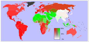
North Africa is strongly dominated by Islam, while Sub-Saharan Africa, with the exception of the Horn of Africa, is mostly Christian. Adherence to these world religions overlaps with traditional or tribal religions and mythologies.
- West Africa
- Akan mythology
- Ashanti mythology (Ghana)
- Dahomey (Fon) mythology
- Efik mythology (Nigeria, Cameroon)
- Igbo mythology (Nigeria, Cameroon)
- Isoko mythology (Nigeria)
- Yoruba mythology (Nigeria, Benin)
- Central Africa
- Bushongo mythology (Congo)
- Bambuti (Pygmy) mythology (Congo)
- Lugbara mythology (Congo)
- East Africa
- Akamba mythology (East Kenya)
- Dinka mythology (Sudan)
- Lotuko mythology (Sudan)
- Masai mythology (Kenya, Tanzania)
- Southern Africa
- Khoikhoi mythology
- Lozi mythology (Zambia)
- Tumbuka mythology (Malawi)
- Zulu mythology (South Africa)
List of countries
Only six African countries are not geographically a part of Sub-Saharan Africa: Algeria, Egypt, Libya, Morocco,Tunisia, Western Sahara (claimed by Morocco). Together with the Sudan, they form the UN subregion of Northern Africa. Mauritania and Niger only include a band of the Sahel along their southern borders. All other African countries have at least significant portions of their territory within Sub-Saharan Africa.
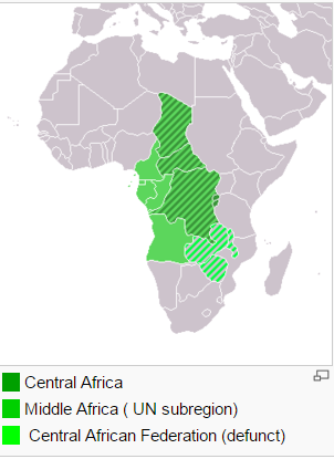
Central Africa
- ECCAS
- Angola (also in SADC)
- Democratic Republic of Congo (also in SADC)
- Rwanda (also in EAC)
- Burundi (also in EAC)
- São Tomé and Príncipe
- CEMAC
Sudan
- Southern Sudan (autonomous region of Sudan with independence referendum in 2011)
East Africa
East African Community
Horn of Africa
Southern Africa / SADC
- Angola (also in ECCAS)
- Botswana
- Comoros
- Lesotho
- Madagascar (sometimes included, not part of the African continent)
- Malawi
- Mozambique
- Mauritius
- Namibia
- Seychelles
- South Africa
- Swaziland
- Zambia
- Zimbabwe
West Africa
- UEMOA
This article is licensed under the GNU Free Documentation License. It uses material from the article "".


